

The Alps – Shanghai Expedition Vehicle Tour
From the Alps to the roof of the world by expedition vehicle!
This expedition vehicle tour is an adventure of superlatives: From the shores of Lake Chiemsee in Bavaria, the route leads through the Balkans, Anatolia, and the Black Sea coast to Central Asia, finally reaching distant Shanghai. Over more than 80 days of travel, self-drivers experience the fascination of the Silk Road, traversing steppe, desert, and high mountains, discovering legendary places like Samarkand, Dushanbe, the Pamir Highway, the Taklamakan Desert, Tibet, and Lhasa.
From Europe to Central Asia – the traces of the Silk Road
The starting point at Lake Chiemsee marks the beginning of a unique overland adventure. With the expedition vehicles we travel through the Balkan countries to Istanbul, the oriental pearl on the Bosporus. After crossing the Anatolian highlands, the route continues along the Georgian Black Sea coast and the mountains of the Caucasus towards the Caspian Sea. In Uzbekistan, we follow the stations of the historic Silk Road. The ancient trading metropolises of Bukhara and Samarkand impress with monumental mosques, madrasas, and lively bazaars. We continue to Tajikistan, where we start in Dushanbe and then venture into the mighty ranges of the Pamir Mountains.
Read more
Pamir Highway – one of the highest roads in the world
The Pamir Highway is considered one of the highlights of any overland journey. Traveling by expedition vehicle, we navigate winding mountain passes, deep gorges, and plateaus at over 4,000 meters. Tajikistan’s unique landscape makes this journey an unforgettable experience. At the end of the highway, the Torugart Pass leads us into Kyrgyzstan before reaching the border with China.
Taklamakan Desert and ascent to the Tibetan Plateau
In China, the Taklamakan, the “Desert of No Return,” awaits. Several days of driving along endless sandy expanses challenge both man and machine, revealing the full dimensions of this unique desert landscape. After this contrast, we ascend from the east to the Tibetan Plateau. Here, high-alpine panoramas, endless expanses, and, as a special highlight, a visit to Everest Base Camp at 5,200 meters await us—a view that is among the most spectacular in the world.
Tibet – Lhasa and the Potala Palace
In the heart of Tibet lies Lhasa, a city steeped in spirituality and history. Together with pilgrims, we explore the alleys of the old town and visit the Potala Palace, the former residence of the Dalai Lama. The atmosphere is steeped in centuries-old traditions and deeply rooted culture. For many participants, Lhasa is one of the emotional highlights of this expedition vehicle tour.
Through Yunnan to Shanghai
After our stay in Tibet, the route continues to Yunnan province – also known as the province “south of the clouds.” Here, we experience the contrast of subtropical valleys, snow-capped Himalayan peaks, tea plantations, and deep gorges. We travel through Shangri-la, Lijiang, and Dali, whose ancient towns are UNESCO World Heritage sites and known for their unique architecture and vibrant markets.
Passing through the world’s largest rice terraces of Yuanyang, we reach the mighty Three Gorges Dam on the Yangtze River. The final leg of our journey brings us to Shanghai, one of the world’s most exciting metropolises. This is where our journey along the Silk Road ends – after over 80 days full of adventure, culture, and nature.
Extend the expedition – to Bangkok
If you haven’t had enough after Shanghai, you can optionally extend the overland tour: The route continues via Laos, Vietnam and Cambodia to Bangkok.
AT A GLANCE
 |
31.07. – 23. 10.2026 | ||||
 |
|
||||
 |
85 days / 84 nights |
||||
 |
Overnight stays in middle-class hotels, guest houses and simple accommodations. |
The Alps – Shanghai Overland Highlights
- Istanbul – Bridge Between Europe & Asia
A full day to explore one of the most fascinating metropolises in the world. Where East meets West – mosques, bazaars, alleys, and history. - UNESCO World Heritage in Anatolia: Safranbolu
A historic Silk Road town with timber-framed houses, bazaars, and rich history – a hidden gem of Anatolia. - The Greater Caucasus & the Steppes of Kazakhstan
Through Georgia’s wild mountain landscapes and Kazakhstan’s endless plains – a blend of challenge, nature, and freedom. - Oases of the Silk Road – Samarkand, Khiva & Bukhara
Three magnificent cities of Central Asia with oriental architecture, lively bazaars, and time for guided city tours. - Pamir Highway – One of the Highest Roads in the World
Crossing Tajikistan at over 4,600 meters: mountain lakes, nomads, yurts, and boundless vastness. - Kyrgyzstan – Caravan Routes & Mountain Trails
Untouched landscapes, ancient nomadic paths, yurts, and pure nature. - Tibet & the Everest Base Camp
Across the legendary Torugart Pass into the highlands of Tibet – up to the Everest Base Camp with views of the world’s highest peaks. - Lhasa, Xigaze & Gyangze – The Heart of Tibet
Visits to Lhasa, the Potala Palace, Jokhang Temple, and the historic sites of the Himalayas. - Yunnan & South China – Tiger Leaping Gorge, Shangri-La & Dali
Rice terraces, Tibetan-Buddhist villages, deep gorges, and UNESCO-listed towns – the dramatic contrasts of southern China. - Finale in Shanghai – Metropolis at the End of the Journey
The journey ends in the vibrant city of Shanghai: modern skyline, colonial old town, the Bund – and reflections on an unforgettable adventure.
![]()
The route is mostly well-maintained and paved. Two-lane roads alternate with small, sometimes single-lane mountain roads. Drivers should be accustomed to safely navigating hairpin turns and narrow, quickly changing curves. Highways are not taken.
![]()
Some sections, up to full day stages, are unpaved. In addition to good gravel roads, some stretches may have potholes and bumps. Certain areas may be covered with sand or pebbles, and there are moderate inclines on unpaved road surfaces. The off-road/paved ratio is approximately 20/80.
![]()
Including breaks, photo stops, and sightseeing, but excluding a lunch break, which lasts about one hour. On regular days, we start in between 8-9am and arrive at the tour hotel in the afternoon. Average times: Approximately 6-7 hours per day
The Alps to Shanghai


The Alps to Shanghai – Itinerary
Day 1: Chiemsee / Traunstein
The journey begins on the shores of Lake Chiemsee. The group meets amidst the Bavarian Alpine foothills, where final preparations are made and everyone gathers for a detailed briefing. The route, organizational procedures, and important information for the coming days are discussed. In this tranquil setting, nestled between the lake and the mountains, an initial atmosphere of optimism and shared determination emerges – the starting point for a long journey southeast.

Day 2: Chiemsee – Zagreb
The next morning, the group sets off. From Lake Chiemsee, the route leads out through the Alpine foothills, past green valleys and wooded ridges. The border with Austria is soon reached, and the landscape becomes more mountainous. Via Salzburg and further towards Carinthia, the road winds through the Alps, accompanied by distant views of peaks and deep valleys. Tunnels and passes alternate until the crossing into Slovenia opens behind Villach. The scenery changes noticeably: rolling hills, vineyards, river valleys. Kilometer by kilometer, Croatia draws closer until we reach Zagreb – a city where Central European architecture blends with southern vibrancy. The old town with its squares, churches, and cobblestone streets invites us to take a first evening stroll after the long stage, before settling down on the outskirts of the city.
Distance: approx. 430 km, Croatia
Day 3: Zagreb – Sabac
From Zagreb, the route continues east. Soon, the Croatian landscape opens up into vast plains, crisscrossed by fields, small villages, and rivers. The road is quiet, the distances become longer, and with each kilometer, the anticipation of the next border crossing grows. The Sava River heralds Serbia, where the atmosphere changes noticeably. The roads are simpler, the towns more pristine, and the landscape appears vast and open. In the afternoon, the group rolls into Sabac, a city on the banks of the Sava, considered the gateway to the Serbian interior.
Distance: approx. 400 km, Serbia
Day 4: Sabac – Nis
From Šabac, the route continues southeast. Initially, the vehicles follow the vast plains of the Sava River, with fields and small villages dominating the landscape. Gradually, the hills gain height, and the road begins to wind in long curves through a diverse landscape. The journey remains entertaining, as open spaces alternate with wooded sections, and views of the region’s river valleys repeatedly emerge. The closer the group gets to Nis, the more clearly the character of the southern Serbian highlands becomes apparent. Here, at the transition between the fertile plains in the north and the rugged foothills of the Balkans, lies the destination: a square just outside the city.
Distance: approx. 320 km
Day 5: Nis – Tsigov chark
The next morning, we continue eastward from Nis, into the gradually changing landscape of southeastern Europe, to the border with Bulgaria, and then on to the tranquil retreat of Tsigov Chark. The area lies high in the Rhodope Mountains, virtually nestled in coniferous and mixed forests – a landscape that becomes quieter and more open with every kilometer covered. Tsigov Chark lies at an altitude of approximately 900 to 1,000 meters and overlooks the Batak Reservoir. Nestled in the Rhodope Mountains, the lake attracts anglers, hikers, and those seeking peace and quiet alike. Ski resorts, hiking trails, and the open sky make it a popular destination year-round. The group finds their overnight accommodation here.
Distance: approx. 320 km, Bulgaria

Day 6: Tsigov chark – Istanbul
From Tsigov Chark, the route continues: across the border, through the mountainous heart of Bulgaria, into the vast Thracian Plain, and on to Istanbul. This stage represents a shift in aesthetics: from the moderate serenity of the mountains through hilly transitional regions to the plain, which suddenly open up to reveal endless fields, historic cities, and the beginnings of the urban chaos of the metropolis. In the early evening, the group reaches the outskirts of Istanbul – a city that divides continents and connects worlds. Between Europe and Asia, an ancient urban structure unfolds here, where Ottoman minarets, Byzantine walls, and modern silhouettes blend into one another.
Distance: approx. 440 km, Turkey
Day 7: Istanbul
After the long journey through Eastern Europe, today offers the opportunity to experience Istanbul in full. The vehicles will stop, and the group will be transferred to the historic center of the metropolis. Here, where Europe and Asia meet, a city experience of exceptional depth unfolds. The day begins with a visit to the Hagia Sophia, whose monumental dome has dominated Istanbul’s skyline for centuries. Once a Byzantine church, later a mosque, and now once again a religious center, it impressively conveys the stratification of cultures and eras.
Read more
Directly opposite stands the Blue Mosque, whose delicate minarets and blue-tiled interiors are among the most important landmarks of the Islamic world.
A walk leads the group to the Hippodrome, the former center of public life in ancient Constantinople. Between obelisks, columns, and expansive squares, the area’s former importance becomes tangible. Finally, the group delves into the labyrinth of the Grand Bazaar – a market that, with its narrow alleys, vaulted ceilings, and thousands of stalls, represents a world of its own. Scents, voices, and colors blend here to create a unique sensory experience.
In the afternoon, the group returns home. The day in Istanbul leaves the group with the feeling of having wandered through millennia of history in just a few hours – a contrast to the tranquil landscapes of the previous days and an unforgettable highlight of the trip.

Day 8: Istanbul – Safranbolu
We leave the European side of Istanbul and head into Asia, into the Anatolian hills, where the roads soon disappear into wooded valleys. The group follows the route to Safranbolu, a picturesque town whose Ottoman half-timbered houses and winding alleys offer a striking glimpse into past centuries. Safranbolu has been a UNESCO World Heritage Site since 1994 thanks to its half-timbered houses. Nestled on the slopes of a verdant landscape, the town feels like an open-air museum that has managed to retain its authenticity to this day.
Distance: approx. 470 km
Day 9: Safranbolu – Kurtulus
Today, a longer stage of the journey awaits: In the morning, the group continues to a camp near Kurtulus. The vehicles leave the main roads and travel along smaller routes, passing villages, fields, and forests. At the destination, a simple, natural spot awaits the group, located directly on the coast and sheltered by trees for a peaceful evening.
Distance: approx. 530 km

Day 10: Gölge Camp –Yusufeli
An early start is recommended today as well. The route is longer and leads through a challenging mountainous landscape, where tunnels, bridges, and switchbacks determine the flow of the road. A large part of the route can be driven along the Black Sea coast, which fascinates with its changing panorama of steep cliffs, small bays, and green mountain slopes.
A stop in Trabzon – a lively port city with a long history, which is an excellent place for a lunch break – is particularly worthwhile. Here, you can explore the narrow streets or enjoy a view of the Black Sea before the group heads further inland. The climb into the Artvin province is impressive: rugged valleys, narrow roads, and views of the rivers that have cut deep into the rock. Yusufeli itself is surrounded by mountains and conveys the feeling of having travelled far away from the main roads.
Distance: approx. 450 km
Day 11: Yusufeli – Cildir
The journey to Cildir takes the group to northeastern Turkey. The roads wind through plateaus and secluded valleys, past small villages and expansive pastures filled with the clear mountain air. With every kilometer, the landscape becomes more barren, yet also more impressive – a transition that already makes the proximity to the Caucasus tangible. The destination lies here – Lake Cildir, a tranquil body of water at almost 2,000 meters above sea level, framed by rolling hills and open spaces. The sky is reflected in its vastness, and the lake’s mood changes depending on the light and weather – sometimes calm and smooth, sometimes turbulent and rough. The campsite is located near the lake. From here, the view extends to the mountains on the border with Georgia, which are not far away.
Distance: approx. 250 km
Day 12: Cildir – Achalziche/Abastumani
From Cildir, the group sets off for Georgia. Although the distance is manageable, crossing the border requires time and patience – formalities and checks dominate the day. However, as soon as the vehicles reach Georgian soil, the atmosphere changes significantly: the valleys appear greener, the roads more vibrant, and the panorama of the mountains heralds the route ahead. The destination is Abastumani, a small town in the hills of the Lesser Caucasus, known for its clear air and healing springs. The access to the observatory above the town offers a welcome change of scenery.
Read more
The route runs along a narrow, partly unpaved track, offering the four-wheel drive vehicles their first real off-road experience in Georgia. Switchbacks wind through forested slopes until the domes of the observatory finally come into view. The spot at the top not only offers impressive views of the mountains, but also a special atmosphere—far from the main roads, in a place that combines science, nature, and tranquillity. This is where the group spends the night.
Distance: approx. 150 km, Georgia
Day 13: Abastumani / Akhaltsikhe – Gori – Tbilisi
We depart from Abastumani or Akhaltsikhe and ride east through the green highlands of Georgia. The route takes us through quiet valleys and agricultural landscapes before passing by Gori. Those who wish to explore the town or stop here for lunch can plan a bit of extra time. We then continue on well-maintained roads as the surroundings gradually become more urban. In the afternoon, we arrive in Tbilisi, a vibrant capital where tradition and modern life come together.
Distance: approx. 240 km

Day 14: Tiflis – Ganja
Leaving Tbilisi behind, we head east toward the Azerbaijani border. The scenery shifts from rolling hills to wide-open plains as the urban environment slowly gives way to rural landscapes. After crossing the border, the scenery changes once more: fields, small settlements and long open roads define our ride through western Azerbaijan. By the end of the day, we reach Ganja, one of the country’s oldest cities, whose relaxed pace provides a pleasant contrast to the days on the road so far.
Distance: approx. 210 km
Day 15: Ganja – Baku
Departing from Ganja, the route leads east through the heart of Azerbaijan. The gently rolling terrain gradually opens into vast plains, shaped by farmland, small villages and long straight roads stretching toward the horizon. Kilometer by kilometer, we draw closer to the Caspian Sea until we finally arrive in Baku – a fascinating metropolis balancing tradition and modernity. Time is available here to make final preparations for the upcoming ferry crossing to Central Asia.
Distance: approx.360 km

Day 16-19: Ferry Crossing of the Caspian Sea
We cross the Caspian Sea by ferry. As there is no fixed schedule and waiting times at the port are common, we remain flexible and adapt to local conditions as needed. Arrival in Beineu, followed by an overnight stay.
Day 20: Beineu – Jasliq
Leaving Beineu, we head south through the vast and arid landscapes of Central Asia. The road cuts through open steppe and desert terrain, where the horizon seems endless and settlements are few and far between. With every kilometer, the surroundings become more remote and untouched, until we eventually cross the border into Uzbekistan. By the end of the day, we reach Jasliq, a remote settlement in Karakalpakstan that offers a striking glimpse into life far from the main travel routes.
Distance: approx. 250 km
Day 21: Jasliq – Moʻynoq
The next day, the route leads to Mo’ynoq, on the former shores of the Aral Sea. The landscape becomes more barren, the wind carries dust over vast expanses once covered by water. In Mo’ynoq itself, the rusting ships now lying on dry sand bear witness to the region’s dramatic environmental history. The group spends the night nearby and has the opportunity to experience the scene of the stranded wrecks – a deeply moving place that reveals the extent of human intervention in nature.
Distance: approx. 270 km

Day 22: Moʻynoq – Khiva
From here, the group continues to Khiva. The route is long, but leads to one of the great pearls of the Silk Road. The group reaches their quarters on the outskirts of the city and has plenty of time the following day to explore the oasis town at their leisure.
Distance: approx. 380 km
Day 23: Khiva
A day’s rest in Khiva offers views of the unique city walls, ornate minarets, and palaces. The historic old town of Itchan Kala, with its blue tiles and narrow streets, is considered one of the most impressive ensembles in Central Asia.

Day 24: Khiva – Gazli
The next stage takes the group to Gazli, a smaller town away from the major tourist crowds. We spend the night here, eagerly anticipating tomorrow’s journey to legendary Bukhara.
Distance: approx. 330 km
Tag 25: Gazli – Bukhara
From Gazli, it’s only a short journey to Bukhara. The day’s drive has been deliberately planned to allow plenty of time to experience this city at its leisure – one of the great pearls of the Silk Road. Bukhara is a place where you can practically feel the Silk Road – in the architecture, in the voices in the bazaars, and in the atmosphere that hovers between past and present. Within the old town, mosques, madrasas, and bazaars are located close together, connected by narrow alleys that tell of life in bygone eras.
Read more
Particularly impressive is the Kalyan Minaret, which has towered over the city’s rooftops since the 12th century and is considered one of the landmarks of all of Central Asia. Labi-Hauz Square, with its shady mulberry trees, invites you to absorb the hustle and bustle of the city, while caravanserais and ornately decorated madrasas reflect the former wealth of the trading city.
Distance: approx. 110 km

Day 26: Bukhara – Samarkand
Finally, the route leads to Samarkand. The name alone conjures up images of splendour and history. After driving through the Uzbek countryside, the city rises with its famous Registan Square, domes, and minarets. Samarkand represents the legacy of Timur Lenk, monumental architecture, and the feeling of being at the center of the history of the Silk Road. This marks the end of a sequence of stages that leads us through the cultural highlights of Central Asia.
Distance: approx. 280 km
Day 27: Samarkand
A day of rest in Samarkand offers the opportunity to explore Tajikistan’s neighbouring Uzbekistan at leisure. From the very first step into the old town, you can sense why Samarkand has been considered a jewel of the Silk Road for centuries. Here, power, art, and spirituality combine in a striking way. The center of the city is the Registan, a square surrounded by three madrasas, which, with its turquoise domes and ornate facades, resembles a stage. But Samarkand has much more to offer: The Gur-Emir Mausoleum reflects the ambitions of Timur, whose rule originated here. The Shah-i-Zinda Necropolis, with its densely packed tombs, appears almost like a kaleidoscope of Islamic architecture, while the Bibi-Khanym Mosque, once one of the largest in the world, offers a glimpse into the past with its imposing ruins.
Read more
What makes Samarkand special today is the juxtaposition of past and present. Between the venerable monuments of the Silk Road rises a modern city with wide boulevards, new parks, and contemporary architecture. Modern cafes, universities, and shops demonstrate that Samarkand is not just an open-air museum, but a vibrant metropolis that carries its historical role as a hub of exchange into the present. This interplay of ancient history and modern everyday life gives the city a dynamism that makes it unique in Central Asia.

Day 28: Samarkand – Urmitan
From Samarkand, the route continues south, across the border into Tajikistan. Crossing the border, as always, takes time, but beyond it, a new landscape opens up with the first foothills of the Fan Mountains. The day’s destination is Urmitan, a small village nestled between mountains and river valleys.
Distance: approx. 130 km, Tajikistan
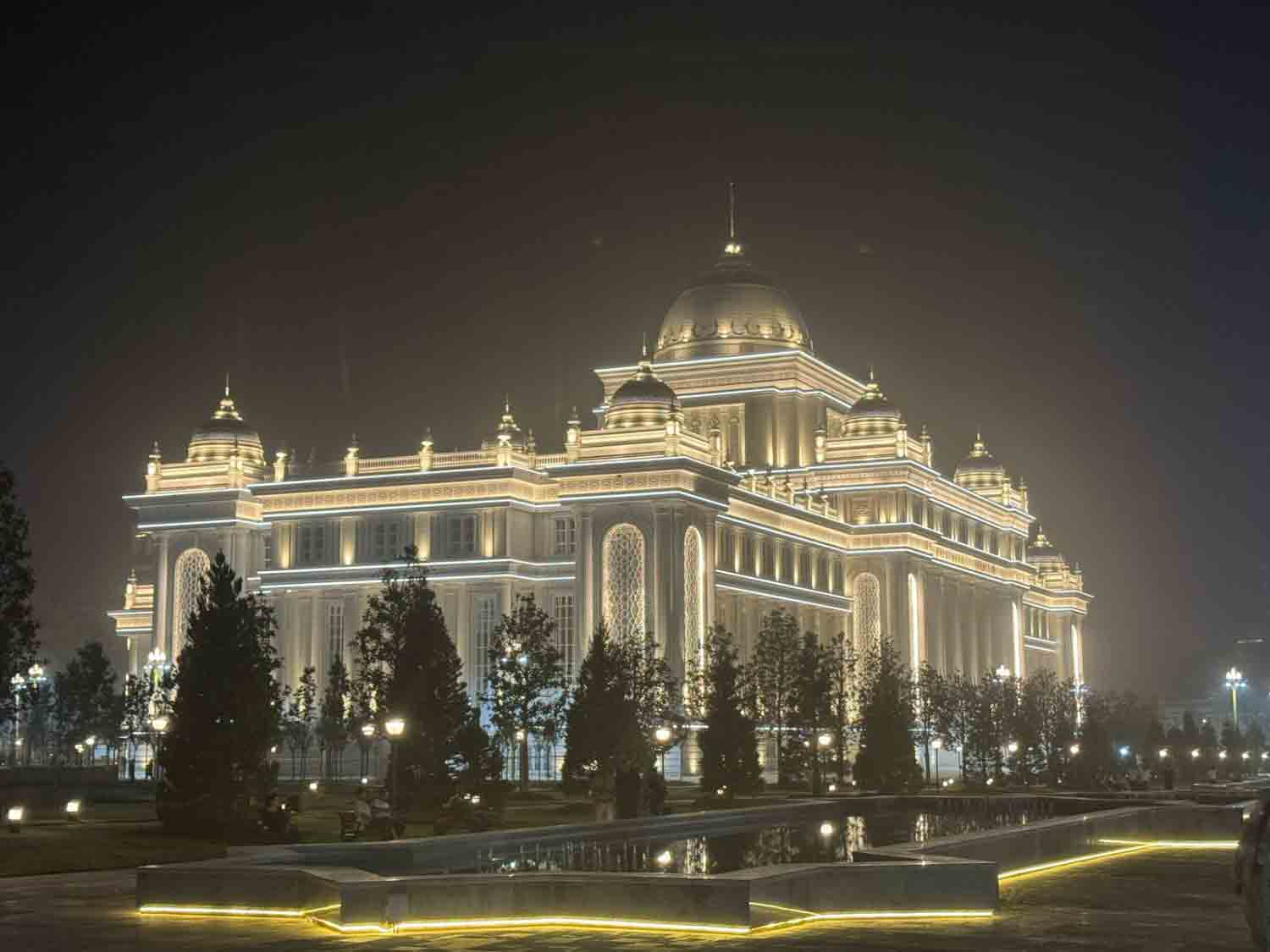
Day 29: Urmitan – Dushanbe
The next stop takes the group to Dushanbe, the capital of Tajikistan. The journey leads through fertile valleys where cotton, fruit, and vegetables thrive, while mountains dominate the horizon in the background. Dushanbe itself presents as a modern city with wide boulevards, parks, and squares characterized by Soviet architecture as well as new, prestigious buildings, which are skillfully lit up at night.
Distance: approx. 180 km
Day 30: Dushanbe – Kulob
From Dushanbe, the journey continues to Kulob. The route runs through agricultural regions where fields, orchards, and small villages dominate everyday life. Kulob is a traditional city in the southeast of the country, steeped in a long history and still a regional center today.
Distance: approx. 190 km
Day 31: Kulob – Kalaikhum
The next day, the route leads to Kalaikhum – a stage that already clearly hints at the character of the upcoming mountain climbs. The roads become narrower, the mountains draw closer, and the landscape appears increasingly rugged. Situated on the banks of the Panj River, Kalaikhum welcomes the group with an impressive backdrop, with houses nestled between the slopes and the riverbed. Afghanistan can already be seen on the other side of the Panj – only a river separates the two countries, whose landscapes stand directly opposite each other here.
Distance: approx. 170 km
Day 32: Kalaikhum – Khorog
From Kalaikhum to Khorog, the road continues along the Panj River, lined with steep cliffs and narrow valleys. The stage is challenging, yet scenically very attractive: small villages open up on the riverbanks, terraced fields cling to the slopes, and the scenery of the Pamirs gradually becomes more tangible. The stage ends in Khorog, the cultural and administrative center of the region. Nestled amidst the mountains, the town offers the first opportunity to experience the special atmosphere of the Pamir region.
Distance: approx. 250 km
Day 33: Khorog – Rabat Sasök-Kul’
From Khorog, the route continues along the Panj River and winds deeper into the high mountains of the Pamirs. The road climbs steadily, the vegetation becomes sparser, and the mountains open up into barren plateaus. The destination is Rabat Sasök-Kul’, a remote spot by a mountain lake. From here, a sweeping view of the Wakhan Valley and the towering mountain ranges of Afghanistan rises. The campsite by the lake exudes peace and seclusion—a place where the tranquility of the Pamirs is particularly haunting.
Distance: approx. 200 km

Day 34: Rabat Sasök-Kul’ – Karakul
The next day’s journey is short, but the scenery remains impressive. The group reaches Karakul, a town on the lake of the same name, located at an altitude of almost 4,000 meters. The deep blue water, framed by peaks, creates a surreal backdrop. The night by the lake is an experience in itself—silence, thin air, and a scenery that is incomparable.
Distance: approx. 240 km
Day 35: Karakul
A rest day in Karakul gives the group the opportunity to quietly take in this special place. Walks along the shore, views of the surrounding mountains, and the play of light and weather over the lake make the stay unforgettable.

Day 36: Karakul – Osh
From Karakul, the route continues to Osh. The journey is long and demanding, and the border crossing into Kyrgyzstan takes time. But the scenery along the way makes up for it: endless plateaus, passes with sweeping views, and finally the descent into the greener valleys of Kyrgyzstan. In the evening, the group reaches Osh, a lively city with an oriental flair.
Distance: approx. 290 km, Kyrgyzstan
Day 37: Osh
A rest day in Osh offers the opportunity to visit the old town, the bazaar and Suleiman Mountain or simply use the time to take care of some errands.

Day 38: Osh – Toktukul Lake
From Osh, the route continues northeast, into the mountains of Kyrgyzstan. The road follows the course of the Naryn River until it finally opens into the enormous water basin of the Toktogul Reservoir. Unlike high-alpine mountain lakes formed by glaciers, Lake Toktogul is a man-made reservoir – created by the construction of the Toktogul Dam in the 1970s.
But this very artificiality also offers a special charm: the water stretches deep blue and wide between bare, steep mountains, shimmering in shades of gold and red in the changing sunlight. On the west shore, near the small town of Torktel, the group finds a suitable place to spend the night. Here, with an unobstructed view over the water, the scenery conveys a special atmosphere – rugged, impressive, and characterized by a vastness that is typical of Kyrgyzstan.
Distance: approx. 280 km
Day 39: Toktukul Lake – Kyzyl-Oi
From the shores of the Toktogul Reservoir, the road winds into the mountains, past gorges, wide valleys, and free-roaming herds of horses. With every bend, new vistas open up, revealing green slopes and rugged peaks, dotted with small settlements and yurts. At the end of the stage lies Kyzyl-Oi, a remote village in the “Red Valley,” whose slopes glow reddish in the evening light. Here, in simple guesthouses amidst the pristine mountain landscape, the group experiences authentic village life in Kyrgyzstan.
Distance: approx. 270 km

Day 40: Kyzyl-Oi – Moldo Ashuu
From Kyzyl-Oi, you have the option of driving the Moldo-Ashuu Pass. The route is both challenging and impressive, as it leads high into the mountains with sweeping views of green valleys and barren peaks. You’ll spend the night near Ak-Terek, where traditional Kyrgyz yurts dominate the landscape.
Distance: approx. 160 km
Day 41: Moldo Ashuu – Tash Rabat
Finally, the group reaches Tash Rabat. This historic caravanserai complex, secluded in a high valley, serves as a striking reminder of the time when Silk Road caravans rested here. The stone walls of the old caravanserai, surrounded by green meadows and towering mountains, provide an atmospheric conclusion to these stages through the heart of Kyrgyzstan. They also signal the imminent crossing of the border into China and the onward journey to Tibet, where a completely new world of culture and high mountains awaits the group.
Distance: approx. 210 km
Day 42: Tash Rabat – Border station near Kashgar – Kashgar
From Tash Rabat, the crossing into China begins – a section that requires both adventure and patience. The road climbs up to the Torugart Pass, one of the crossings between Kyrgyzstan and the Middle Kingdom. With every kilometer, the route becomes rougher, the asphalt giving way to potholes and dirt roads, until finally, only an adventurous gravel road marks the way. At the top of the pass, at an altitude of over 3,700 meters, the Kyrgyz-Chinese border awaits the group. After entering the country, we initially drive down, but the vehicles are not allowed to continue directly to Kashgar: they are parked about 120 kilometers away from the customs station. From here, an organized transfer takes the group to the city in the afternoon, while the vehicles are not picked up until the following morning.
Distance: approx. 220 km, China
Day 43: Kashgar
The following day is dedicated to formalities in Kashgar. Temporary Chinese driver’s licenses and license plates are issued at the local traffic office. A brief medical check and vehicle inspection are also required. These procedures take time, and the organization is a collective effort – patience is the most important virtue on this day.
Distance: approx. 150 km

Day 44: Kashgar
An additional day in Kashgar will be reserved in case the process takes longer. For the group, however, this isn’t just a wait, but an opportunity to experience one of the most fascinating cities on the ancient Silk Road. The old town, with its mud houses, winding alleys, and colorful markets, conveys a sense of Kashgar’s centuries-old importance as a caravan hub. In the evening, the city comes alive: vendors, music, aromas, and the famous grilled meat, which is considered some of the best in China, make the stay an experience that makes the bureaucratic part of immigration disappear.
Day 45: Kashgar – Aksu
From Kashgar, the route continues east to Aksu. The landscape along the route already reveals the typical contrasts of the Tarim Basin: arid plains, sand and stone deserts on one side, and the towering Tianshan Mountains beyond. The roads are well-maintained, yet the landscape seems almost endless. Aksu itself is a modern city with a Uyghur character.
Distance: approx. 460 km

Day 46: Aksu – Kuqa
The next day, the group rolls to Kuqa. This section begins the long journey along the northern route to Lhasa. Kuqa, once an important stop on the ancient Silk Road, is known for its Buddhist caves and historic temples, testifying to the region’s cultural richness.
Distance: approx. 370 km
Day 47: Kuqa – Korla – Boston Lake
From Kuqa, we continue to Korla and from there to Boston Lake, China’s largest inland lake. The water shimmers blue and turquoise, surrounded by a barren, semi-desert landscape—a striking contrast that defines the charm of this region.
Distance: approx. 350 km

Day 48: Boston Lake – Turpan
The next leg of the journey takes the convoy to Turpan, an oasis town on the edge of the Taklamakan Desert. The climate is extreme; in summer, Turpan is one of the hottest places in all of China, but the fertile soils surrounding the town allow for the cultivation of wine, melons, and fruit. From here, some of the region’s most important sights can be explored the following day.
Distance: approx. 340 km
Day 49: Turpan
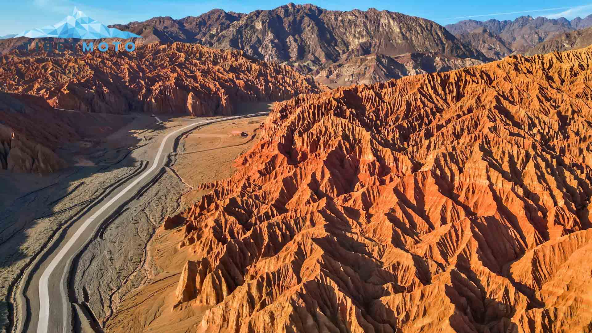
A rest day in Turpan offers the opportunity to intensively explore one of the most fascinating oasis cities on the Silk Road. Here, on the edge of the Taklamakan Desert, extreme climatic conditions combine with millennia-old cultural history. The group visits the ruins of Yarkhoto (Jiaohe), an abandoned mud settlement that impressively testifies to the size and importance of this region in ancient times. Also on the itinerary are the Astana Tombs, with their artfully preserved wall paintings and grave goods, which offer a direct glimpse into the life of bygone eras. The Buddhist caves, with their frescoes, also illustrate the cultural exchange that once took place along the trade routes. Finally, the journey to the Flaming Mountains, whose bright red rocks appear to glow in the sunlight, is impressive – a sight that makes Turpan a highlight on the route through Xinjiang.
Day 50: Turpan – Hami
From Turpan, the route continues to Hami, another oasis town on the historic Silk Road. Here, where desert and mountains meet, the sequence of stages through Xinjiang continues in an atmosphere of contrasts and history—a harbinger of this adventurous journey that will lead to Tibet.
Distance: approx. 410 km
Day 51: Hami –Dunhuang
From Hami, the route continues east to Dunhuang, a city on the western edge of the Gobi Desert, located in the so-called Hexi Corridor. Even the approach conveys the character of this region: barren plains, wind-carved dunes, and the rocky outcrops of the Hexi Corridor, which has marked the trade route between China and Central Asia for centuries. Due to its location, Dunhuang is still considered the gateway to the great deserts.
Distance: approx. 410 km

Day 52: Dunhuang
A rest day in Dunhuang offers the opportunity to experience this city on the edge of the Gobi Desert off the beaten track. Once an important hub on the Silk Road, today it impresses with lively bazaars, traditional alleys, and the contrast between sand dunes and oases. Highlights include the Mogao Grottoes, a UNESCO World Heritage Site with thousands of Buddhist murals, as well as the up to 170-meter-high dunes of Mingsha Shan, at the foot of which Crescent Lake lies, resembling a green jewel. Thus, on a rest day, Dunhuang combines the tranquility of the desert with cultural diversity and the bustling life of the city—before the journey continues.
Day 53: Dunhuang – Goldmud
From Dunhuang, the route continues to Golmud, initially through vast plains that gradually rise to the heights of the Qinghai-Tibet Plateau. Located at an elevation of approximately 2,800 meters, Golmud is a vast city despite its comparatively small population – its administrative area covers over 100,000 square kilometers. Its highland location brings with it extreme climatic conditions: In summer, temperatures climb to as high as 35 degrees Celsius, while in winter, temperatures of minus 30 degrees Celsius and below are not uncommon.
Distance: approx. 540 km

Day 54: Golmud – Tanggulazhen
The next stage, to Tanggulazhen, takes the group even deeper into the Qinghai-Tibet Plateau. The road climbs steadily, and the highlands reveal themselves in all their vastness: bare hills, clear air, endless horizons.
Distance: approx. 420 km
Day 55: Tanggulazhen – Amdo County
From Tanggulazhen, the journey continues to Amdo County, where Tibetan culture is already evident. The drive through this high-altitude region requires careful attention, but the landscape, with its vast plains, mountain passes, and small nomadic settlements, makes up for the effort.
Distance: approx. 280 km
Day 56: Amdo County – Damxung
The next stage to Damxung leads over the La Ghen La Pass, which, at over 5,000 meters, is one of the highest points of the journey. From here, the view extends far across the Tibetan Plateau. Damxung itself lies amidst vast grasslands, where yak herds and nomad camps dominate the landscape.
Distance: approx. 340 km
Day 57: Damxung – Shigatse
From Damxung, the group travels to Shigatse, Tibet’s second-largest city. Here, the Tashilhunpo Monastery, seat of the Panchen Lama, rises with its golden roofs and enormous monastic complex. Between ancient pilgrimage routes and modern city life, Shigatse is a place where the profound spirituality of Tibet is immediately tangible. The combination of vibrant everyday life, impressive monastic art, and centuries-old history makes a stay here one of the cultural highlights of the entire trip.
Distance: approx. 330 km

Day 58: Shigatse
A rest day in Shigatse offers time to visit the Tashilhunpo Monastery, founded in the 15th century and still considered the seat of the Panchen Lama. The sprawling complex, with its golden roofs, red walls, and winding courtyards, is a highlight of any trip to Tibet. Inside are enormous statues, including the 26-meter-tall Maitreya Buddha—the largest gilded statue of its type in the world. Pilgrims circumambulate the monastery walls on the kora path, accompanied by fluttering prayer flags and the sound of prayer wheels.
Read more
But Shigatse offers even more: The old town surrounding the monastery, with its markets, craft shops, and traditional houses, offers an authentic picture of Tibetan life. Here, you can discover finely woven carpets, intricate thangka paintings, and silver jewelry. The Shigatse Dzong fortress, which towers high above the city, also reminds us of the political importance of the place – it was once the residence of regional rulers and today offers a wide view over the Yarlung Tsangpo valley.
Day 59: Shigatse – EBC
From Shigatse, the route leads along one of the most spectacular roads in Tibet, if not the world. With countless twists and turns, it climbs to passes that offer a panorama of the highest mountains on earth. From here, the view extends to the mighty eight-thousanders Shisha Pangma, Cho Oyu, Lhotse, Makalu – and, of course, Everest itself. After a stopover in Tingri, the journey continues until reaching Rongbuk Monastery at an altitude of almost 4,900 meters. The final kilometers to the monastery are not permitted in private vehicles – instead, a local transfer takes over the final section.
Read more
Even though the actual base camp has been inaccessible since 2019, Rongbuk offers an unparalleled view of the 8,848-meter-high summit. The unobstructed view of Everest is a moment that rewards all the effort. The overnight stay is not far from the parked vehicles, amidst the rugged high mountain landscape of the Himalayas.
Distance: approx. 290 km

Day 60: EBC – Sakya
From the heights of Everest Base Camp, the route leads back over the winding roads of the Himalayas to Sakya. This place is famous for its monastery, whose massive gray walls almost resemble a fortress and are a marked departure from the otherwise mostly whitewashed Tibetan monasteries. Sakya is considered the spiritual center of its own Buddhist school, and with its ancient libraries and halls, it conveys a sense of deep history and spirituality.
Distance: approx. 200 km
Day 61: Sakya – Gyangze
The next day, the group continues to Gyangze. The journey leads through plateaus and wide valleys, where yaks and nomad camps dominate the landscape. Gyangze itself is a small but traditional town, whose landmark is Tibet’s largest stupa.
Distance: approx. 230 km
Day 62: Gyangze – Lhasa
From Gyangze, the route continues to Lhasa, the cultural and religious heart of Tibet. The route leads over the Karo La Pass at an altitude of approximately 5,100 meters, where glaciers reach almost to the road, offering impressive views of snow-capped peaks and the azure Yamdrok Lake. The route then winds its way through valleys and plateaus until it reaches the entrance to Lhasa—a special moment at the end of the long overland journey through Central Asia.
Distance: approx. 260 km
Day 63: Lhasa
A rest day in Lhasa allows you to experience the city more fully. At the Bharkor Market, pilgrims, traders, and travelers throng through alleys full of scents and colors. Towering above all is the Potala Palace, the former residence of the Dalai Lama, whose white and red walls dominate Lhasa’s skyline. Equally important is the Jokhang Temple, the spiritual center of Tibet and a destination for countless pilgrims from all parts of the highlands.

Day 64: Lhasa
The group visits the Potala Palace.
Day 65: Lhasa – Nyingchi
The journey continues east from Lhasa to Nyingchi. The road winds through green valleys and spectacular gorges carved by the waters of the Yarlung Tsangpo River. At approximately 3,000 meters, Nyingchi lies significantly lower than Lhasa and is often referred to as the “Garden of Tibet” due to its mild climate and forested slopes. Here, a completely different character of the country is revealed: fertile soils, dense forests, and an almost subtropical ambience that stands in stark contrast to the barren plateaus of central Tibet.
Distance: approx. 400 km
Day 66: Nyingchi – Ranwu Lake
From Nyingchi, the group crosses various mountain passes reaching elevations of up to 5,100 meters before reaching Lake Ranwu, a turquoise-blue body of water amidst snow-capped mountains and dense forests. The journey there offers repeated views of river valleys and peaks – a striking interplay of high mountains and lush vegetation that highlights the diversity of the Eastern Himalayas. The region is therefore also known as the “Switzerland of the Orient.”
Distance: approx. 370 km
Day 67: Ranwu Lake – Zogang
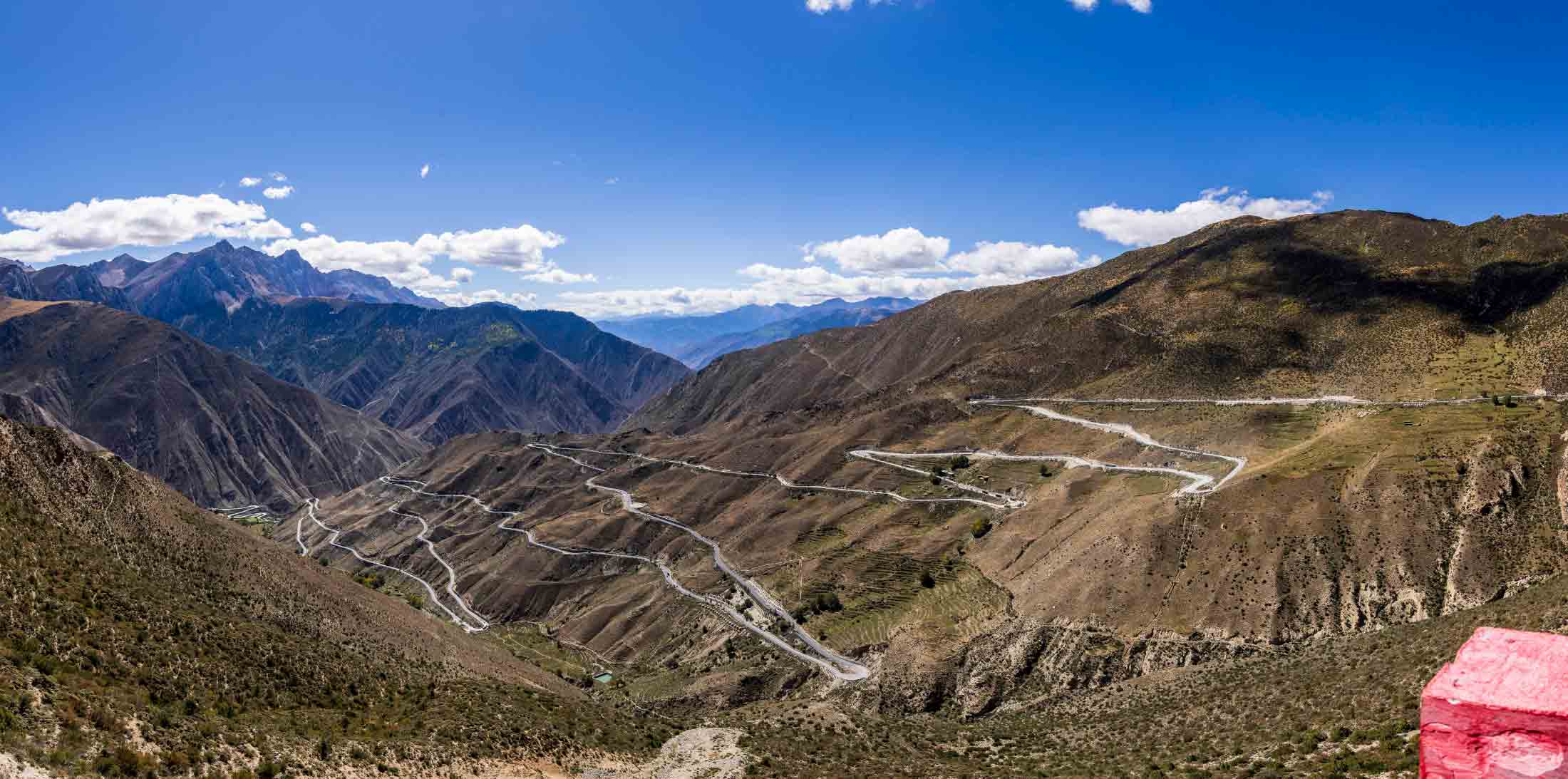
We follow the road along the lakeshore toward Zogang. The first part of the day leads through narrow gorges where the river has cut deep into the rocks. A driving highlight awaits: the infamous Snake Pass, known to locals as the “Road of 72 Bends.” The route winds its way up to over 4,300 meters in endless switchbacks. Each section offers new perspectives on the wide-open valley, the snow-capped peaks in the distance, and the seemingly endless succession of hairpin bends.
Once at the top, the pass rewards us with a sweeping view of the mountains of eastern Tibet before the road descends again in long loops. This passage is one of the most impressive stretches of the entire trip—a mixture of technical challenge and dramatic scenery that will stay with you forever.
Distance: approx. 300 km

Day 68: Zogang – Markham
From Zogang, the journey continues to Markham, a key transportation hub on the eastern edge of Tibet. This is where the routes to Yunnan and Sichuan converge. The journey there leads through gorges and across high plateaus, past nomad camps and pastures. Markham is less characterized by its sights than by its role as an interface between the cultures and roads of the Eastern Himalayas.
Distance: approx. 160 km
Day 69: Markham – Jiabe Homestay
The next day, the group reaches the Jiabe Homestay via remote roads. The stage is shorter but scenic: small river valleys, villages, and fields dominate the landscape. A stay in a traditional homestay offers the opportunity to experience everyday Tibetan life up close – a glimpse into the lives of the people who have lived here for generations amidst a barren mountain landscape. The cozy accommodation is located at an elevation of approximately 1,900 meters, within walking distance of a magnificent viewpoint of the Mekong Gorge.
Distance: approx. 240 km

Day 70: Jiabe Homestay – Shangri-La
From the homestay, the route continues to Shangri-La. This name evokes the image of a mythical “hidden paradise.” The city is located in Yunnan Province and marks the transition from the Tibetan plateau to a region with a more strongly Chinese influence. Monasteries, markets, and the blend of Han and Tibetan culture make Shangri-La a special stopover. Small, two-story wooden houses with detailed carvings adorn the beautiful old town, lending the place a unique atmosphere.
Distance: approx. 190 km
Day 71: Shangri-La – Tiger Leaping Gorge – Lijiang
Another highlight follows the next day: the drive through the Tiger Leaping Gorge on the way to Lijiang. The Jinsha River rushes between three-kilometer-high cliffs, flanked by the mighty chain of the Jade Dragon Snow Mountain, which towers over 5,500 meters. This dramatic landscape is one of the deepest gorges in the world and offers a first-class natural experience. In the evening, the group reaches Lijiang, whose UNESCO-protected old town, with its winding canals, bridges, and traditional Naxi houses, offers an incomparable atmosphere. This day also marks the end of the Tibetan phase of the trip—now the immersion in Naxi culture begins.
Distance: approx. 190 km

Day 72: Lijiang
A rest day in Lijiang allows you to explore the old town more intensively, stroll through narrow alleys and enjoy the mix of history and lively everyday life.
Day 73: Lijiang – Dali
From Lijiang, it’s only a short drive to Dali. The old town, with its well-preserved Ming Dynasty city wall and the famous Three Pagodas of Chongsheng Temple, is a significant testament to its history. Excursions by boat or bike around Erhai Lake are ideal, while the Cangshan Mountains beckon with hiking trails and a cable car. In the evenings, the lively Huguo Street, also known as “Foreigner Street,” creates a vibrant atmosphere with its restaurants, cafés, and shops.
Distance: approx. 180 km

Day 74: Dali – Kunming
From Dali, the journey continues to Kunming, the capital of Yunnan Province. The route travels briskly along the highway, while the landscape is characterized by alternating mountains, valleys, and agricultural plains. Kunming, known as the “City of Eternal Spring,” welcomes the group with a mild climate and a vibrant blend of tradition and modernity.
Distance: approx. 400 km
Day 75: Kunming – Xingyi
The next stage takes the group to Xingyi, where the Qianxinan karst region dominates the landscape. Rugged limestone formations, deep gorges, and verdant hills create an impressive backdrop, emphasizing that the journey now shifts to the subtropical south of China.
Distance: approx. 280 km
Day 76: Xingyi – Guiyang
From Xingyi, the route leads to Guiyang, the capital of Guizhou Province. The city is located in a hilly region and is known for its ethnic diversity – numerous minorities live here, whose culture and markets enrich the cityscape.
Distance: approx. 340 km
Day 77: Guiyang – Fenghuang
The onward journey to Fenghuang takes the group to one of China’s most beautiful ancient towns. Situated directly on the river, with wooden houses built on stilts, narrow alleys, and traditional stone bridges, Fenghuang exudes a unique historic charm. Here, time seems to have stood still.
Distance: approx. 370 km

Day 78: Fenghuang – Zhangjiajie
From Fenghuang, we continue to Zhangjiajie, a region known worldwide for its bizarre sandstone formations. The steeply rising pillars and rock towers, often shrouded in mist, evoke a surreal fairytale landscape—and served as the inspiration for the floating mountains in the film “Avatar.”
Distance: approx. 210 km
Day 79: Zhangjiajie – 3 Gorges Dam
The next stage takes the group to the Three Gorges Dam on the Yangtze River. This gigantic structure is considered the largest hydroelectric power plant in the world and impresses with its immense dimensions, as well as its scenic location amidst the famous Three Gorges.
Distance: approx. 350 km

Day 80: 3 Gorges Dam – Wuhan
From here, we continue to Wuhan, one of the major metropolises of central China. Located at the confluence of the Yangtze and Han Rivers, the city combines modern architecture with historic sites, such as the Yellow Crane Tower. Wuhan also marks a clear step into the heart of the country—a melting pot of culture, history, and dynamism.
Distance: approx. 360 km
Day 81: Wuhan – Anqing
From Wuhan, the route continues east to Anqing, a city on the banks of the Yangtze River. The journey leads through densely populated areas with a constant alternation of towns, fields, and small hill ranges. Anqing itself is an ancient port city with a long history and, at the same time, a transportation hub that takes the group deeper into the economically important regions of eastern China.
Distance: approx. 360 km

Day 82: Anqing – Taihu Lake
The next day, we continue from Anqing toward Lake Taihu. It is one of China’s largest freshwater lakes, nestled in a gently rolling, fertile landscape, and has been considered a cradle of poetry, painting, and garden art for centuries. Its shores are dotted with tea plantations, fishing villages, and ancient water towns—a transition to the cultural landscapes that have made eastern China so famous.
Distance: approx. 390 km
Day 83: Taihu Lake – Shanghai Port
The final leg of the journey finally leads to the final destination: Shanghai. Along the way, the landscape becomes increasingly urban, and the silhouette of the metropolis announces the end of the long journey from afar. Shanghai, China’s vibrant economic metropolis, welcomes the group with a modern skyline, colonial architecture on the Bund, and an inexhaustible array of culture and life.
Distance: approx. 180 km
Day 84: Buffer day
A buffer day in Shanghai provides the opportunity to either explore the city – perhaps with a stroll along the Bund promenade, through the old town with its classical gardens, or through the modern Pudong financial district – or to take your time preparing for the shipping of the expedition vehicles.
Day 85: Shanghai
On the last day in Shanghai, the vehicles are loaded. The handover of the expedition vehicles marks the end of this incredible adventure, which led from the Alps through Central Asia, Tibet, and China to the Pacific coast. It’s a moment to reflect on thousands of kilometers full of impressions, encounters, and unforgettable landscapes. Not many people experience such a journey.

Your Most Unforgettable Car Adventure is just a Click away!
Book now your Roadtrip Eurasia Expedition Vehicle Tour
Book NOW your „Roadtrip Eurasia Expedition Vehicle Tour“!
Due to the high number of tour requests, you should decide quickly!
Our Next available tours are as follows:
2026
31.07. – 23.10.
Included Services
- All necessary parking and camping sites along the route are included in the tour price
- English-speaking tour guide with own vehicle.
- Mechanic accompanying the tour, universal tools, tire repair kit, etc.
- Rotating, local guides for numerous countries who speak the local language and are familiar with the culture. These countries include Turkey, Kazakhstan, Uzbekistan, Tajikistan, Kyrgyzstan, and Tibet/China.
- Support vehicle for technical service.
- Pamir Highway: GBAO Permit + special permit for the Kyzyl-Art Pass border
- All official permits for Tibet/Temporary import of a foreign-registered vehicle into China:
– Temporary Chinese driver’s license
– Temporary Chinese license plate
– Deposit for the vehicle with Chinese customs
– Mandatory vehicle insurance
– Customs clearance upon entry and exit
– All permits for China and Tibet
– All official translations - State-approved and required Tibet guide (English-speaking) from the Chinese border and for the whole of Tibet
- All entrance fees according to the program
- City tours in Istanbul, Safranbolu, Amasya, Bukhara, Samarkand, Khiva, Kashgar, Lhasa, Dali, Shanghai
- Flight advice Shanghai – Europe at the end of the main trip
- Hotel parking costs (except Munich for organizational reasons)
- Support for entry into Turkey, Azerbaijan, the Central Asian states and China
Excluded Services
- Long-haul flight from Shanghai back to Germany
- Vehicle shipping from Shanghai to Hamburg at approximately €8,000-12,000 per vehicle, including all port and customs clearance fees.
- Gasoline/diesel, lunch and dinner, as well as snacks and beverages
- Travel cancellation insurance
- Car pickup in Hamburg after return shipping
- Visa fees
- Toll fees
- Vehicle insurance costs
Questions & Answers
Simple street maps are often available locally. The best road maps are available from the German publishers Reise Know How and Nelles. These are only available in specialized bookstores or online.
Your baggage will be carried by the support vehicle. Please don’t pack too much – remember: less is more. From time to time, we’ll have to carry our baggage over short distances to the hotel. Baggage is not insured, so please be sure to purchase your own baggage insurance for the trip if necessary. Your personal items for the day are best kept in the saddlebags or your daypack. Tank bags – including magnetic ones – can be used on the Enfields, but we don’t provide them.
Our European tour guides are skilled motorcyclists and inveterate travelers who love India. They’re resilient in the face of stress and know the history and culture of the regions they cover. Our Indian mechanics are experienced Enfield specialists who all speak English and are happy to help with any technical problem, great or small.
A stand-in rider is always available. More information on our travel concept is available here.
A travel day normally begins at 8 am with breakfast. Around 9 am, after a short briefing by the road captain, it’s time for the day’s riding, the mileage of which can vary quite a bit. Plenty of time will be available for lunch and coffee breaks, of course. Depending on the day’s mileage, we’ll reach the destination hotel between 3 and 4 pm.
Since our tours vary considerably, we may also hit the road at 8 am on high-mileage days – which is also nice, because then we have the whole day ahead of us.
Riding two-up is almost always possible. In difficult terrain or on rough tracks, every passenger has a guaranteed seat in the support vehicle to keep things relaxed for both rider and pillion.
Depending on the specific tour, the following bikes are available for our motorcycle tours in Tibet and China: The BMW models G 310 GS, F 800 GS and R 1200GS, as well as the Shineray X5, a 400cc single-cylinder enduro.
You will definitely want to bring your riding suit with protectors and a helmet. You will also need motorcycle boots or lighter riding shoes and gloves. While your gear should be breathable in hot climates, you need to be ready for anything at high altitudes and in the Himalayas. We recommend winter gloves, warm socks, liners for jackets and trousers, a scarf and face protection. Rain gear is a good idea if your riding suit is not waterproof.
Please note that we do not hire out clothing. We believe that your own riding gear will fit best and thus give you the best protection. If you forget anything, we’ll find a solution, however. We often have spare gear with us, or we can point you in the direction of a shop.
You will need your passport, national driving license, international driving license and flight ticket. Please be sure to make photocopies of all of your important travel documents and carry them separately. They can be invaluable in an emergency.
The deposit for the motorcycle varies depending on the choice of bike:
Shineray X5 400: EUR/US$ 500
BMW G 310 GS: EUR/US$ 1,000
BMW F 800 GS and R 1200 GS: EUR/US$ 1,500
Groups generally consist of 8 to 14 riders and 2 to 6 passengers. The minimum number of participants is 6 riders.
Yes, all passengers have a guaranteed seat. In bad weather or challenging riding conditions, they can switch to the support vehicle at any time – and back to the bike when conditions improve.
We always recommend that you take out travel insurance to cover costs incurred if you need to cancel the trip due to illness or other reasons. When shopping for travel health insurance, make sure the policy covers the potentially high cost of medical evacuation to your home country. Both forms of insurance can save you a lot of money in an emergency and we recommend them unreservedly. In many countries, your national motoring organization can provide the coverage you need.
All riders must have a valid motorcycle driving license issued in their home country. An international driving license is also required. Be sure to contact the relevant authorities in your home country well in advance for more information on obtaining an international driving license.
Entry/Visa:
Many nationalities can enter China visa free for up to 15 days. Those include:
Germany, France, Italy, The Netherlands, Spain, Malaysia, Switzerland, Ireland, Hungary, Austria, Belgium, Luxembourg, New Zealand, Australia, Poland.
Your passport must be valid for at least 6 months. Some other nationalities need a visa to enter China.
Should the duration of the stay exceed 15 days, you must apply for the visa yourself or hire an agency to do so. Due to frequent changes in the application procedure, we recommend using an agency. Although you can apply for the visa yourself, it is only slightly more expensive to hire an agency and often saves a lot of work. The visa for China costs approximately EUR 300. More detailed information on the visa can be found in a specific appendix after booking upon request.
Tour Concept by RC Hendrik
